Roads are veins
-PM Narendra Modi
and arteries of the nation, which help
to transform the pace of development
and ensure that prosperity reaches
the farthest corners of our nation.”
Introduction – Delhi’s 3rd Ring-Road
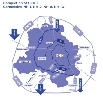
UER 2 will be inaugrated on 16th August, 2025 by Prime Minister Narendra Modi. Delhi’s traffic woes have been around for years. The future, 3rd Ring Road area, UER-2 concept was part of the 1962 Delhi Master Plan. A first-order access-controlled expressway, UER-2 will serve as the 3rd Ring Road along Delhi’s western edge. It will help to connect multiple Indian highways NH-1, NH-2, NH-8, and NH- 10 all as part of the Bharatmala Pariyojana. It will ease congestion, improve freight efficiency, and provide new development zones.
For investors, high-growth real estate and logistics corridors.
For UPSC aspirants, a live case study on infrastructure policy, national highway strategy and impact on the economy.
UER-II – Quick Facts
- Purpose: Divert heavy vehicle traffic away from the city, remove congestion and improve connectivity.
- Length:
Phase 1 – 49 km – (NH-1 to NH-8, with a possible extension to Nelson Mandela Marg)
Phase 2 – Nelson Mandela Marg to Badarpur - Connections: NH-1, NH-2, NH-8, NH-10.
- Key Areas: Najafgarh, Rohini and Dwarka.
- Noteworthy stretch: 7.5 km Dwarka – Shiv Murti stretch (Dwarka Expressway section).
Public Private Partnerships (PPP) in UER-II
UER-II is being developed under the Bharatmala Pariyojana with a Hybrid Annuity Model ( in common parlance, a “PPP”).
In this model:
- Government funds 40% of the project costs in the construction phase;
- 60% is borne by a private concessionaire, who finances it through debt/equity, and is repaid by the government over 15–20 years, including interest, and performance based payments.
- Private firms are responsible for design, construction, operation and maintenance during the concession period: adding efficiency, and quality controls.
- This model allows the government to defer financial burden for the immediate future (alongside maintaining payments over the concession period) while allowing the government to utilize efficiencies in the private sector.
- Under a PPP framework in UER-II, the developer is able to collect toll revenues and part of the toll revenues can be used for operational costs and loan repayment.
Investor Importance – UER-II is Golden Investment Opportunity
- Price Appreciation – Areas like Rohini, Narela, Bawana, and Dwarka prices have already increased appreciably due to their proximity to the new proposed expressway. (Few list of dealers are mentioned here.)
- Logistics Advantage – Will significantly reduce freight travel time between Gurugram, Manesar, and Sonipat – no requirement to enter jambers of delhi road.
- Airport Connectivity – Gives a shorter and faster route to Indira Gandhi International (IGI) Airport from North West and South West Delhi.
- Industrial Development – The anticipated warehousing hubs, Logistics parks, and Industrial zones in the entire corridor will ultimately create more jobs and foster economic activity.
List of Important Highways of India
| Highway | Route | Notable Fact |
|---|---|---|
| NH 44 | Srinagar to Kanyakumari | Longest NH in India |
| NH 27 | Porbandar to Silchar | Second longest |
| NH 1 | Delhi to Amritsar | Connects Delhi with Punjab |
| NH 16 | Kolkata to Chennai | East coast route |
| NH 48 | Delhi to Chennai via Mumbai, Bengaluru | Part of Golden Quadrilateral |
| NH 66 | Mumbai to Kanyakumari | West coast corridor |
| NH 19 (Old NH 2) | Delhi to Kolkata | Passes through Varanasi |
| NH 52 | Punjab to Assam | Crosses northeast plains |
Bharatmala Pariyojana – The Parent Scheme
Year Launched: 2017
Implementing Agency: National Highways Authority of India (NHAI)
Objective
To create an integrated road network that will:
- Improve freight efficiency across the country by Reducing logistics costs from ~14% of GDP to ~9%.
- Plug crucial infrastructure gaps, and
- Grow India’s economy by providing coordinated access to the country’s economic corridors, borders & border areas, ports and backwaters.
Targets
Phase I: 34,800 km of highways to be delivered by 2025-26 (UER-II included).
Overall – about ~35,000 km of national highways under the scheme.
Reducing logistics costs – from ~14% of GDP to ~9% GDP.
Key features
- Economic Corridors – linking the developed major industrial and commercial hubs
- Inter-corridor & feeder routes – allowing seamless movement between highways
- National corridor efficiency improvement – identifying & upgrading critical congested stretches.
- Border & international connectivity roads – improving trade & security.
- Coastal & Port Connectivity Roads – enabling Sagarmala ports development.
- Greenfield expressways – high-speed connectively (i.e. UER-II).
UPSC Connection – Highways in Year Before Year Questions
Highways often appear in UPSC Prelims as they play an important role in:
- Location Identification – locating routes, cities adjoining highways routes.
- Projects and Scheme Linkage – linking projects to large flagship schemes either under Bharatmala Pariyojana, Sagarmala.
- Economic Impacts – as highways are important in reducing Logistics costs, increasing Trade.
PYQ References:
- 2020: Asian Highway Network – routes and which countries included.
- 2016: Golden Quadrilateral – major cities and corridors.
- 2014: Identification of certain national highways via the map.
Possible Questions on UER-II:
- Which National Highways does it connect?
- Under which scheme is it being developed? (Bharatmala Pariyojana)
- Environmental concerns with massive highway projects.
- Map based question on its route and connections.
Drawbacks & Ground Issues of UER-II
- Disruption of Connectivity at Rani Kheda
The corridor has a gap in the Rani Kheda stretch where work is still ongoing with some incomplete stretches necessitating small diversions. - Incomplete Junction Links
The planned opening of UER-II on 16 August 2025 has not yet been realized with some of the connecting stretches remain incomplete, thus impacting operational efficiency in the near term. - Incomplete Ancillary Infrastructure
Other incomplete aspects of the expression way are also affecting operational safety and traffic efficiency, including missing service lanes, incomplete signage and partially installed safety barriers in several areas. - Tolls May Be A Problem
Multiple toll booths located along the expressway increase the overall cost of travel for daily users and commercial traffic operators given their fixed daily cost of travel and can also disincentivize daily users. This is particularly true for travelers who do short distances as the time saved may not make sense for tolls. - Inconsistencies In Agency Coordination
In at least one example, both the NHAI, PWD, and DDA all shared responsibility and sometimes have different views on their priority which often leads to delays in fully integrating and completing works on the extended route. - Local Impact Issues
Residents in the area have complained about the dust and noise pollution and overall disruptions from the ongoing completion works leading up to the opening day.
Conclusion – Beyond a Road
The Urban Extension Road-II is not simply a transportation project but a strategic corridor that will relieve congestion in Delhi, improve inter-state freight movement and connect urban and rural Delhi to the national expressway map. Part of the Bharatmala Pariyojana, the project simultaneously links disparate parts of our economy and represents India’s larger vision of growth by connecting economic spaces. For the UPSC students, UER-II is the ideal case study to understand how infrastructure, trade, environment and governance all overlap at once.
For more such articles subscribe to Infotrigg.com


informative