Introduction
As per the United States Geological Survey (USGS), over 20,000 earthquakes occur around the globe each year, with about 16 of them considered major (magnitude 7 or above).
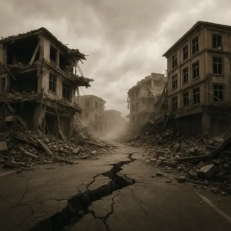
The world is being forced to acknowledge that most so-called “natural” hazards, as COP 30 approaches, are increasingly human-induced in terms of scale and intensity. Rising seas have forced a Caribbean island to evacuate, and island nations are teetering on the brink of submersion. In India, disasters such as the Dharali flood and the Punjab–Himachal floods remind us of nature’s retaliation against the reckless extraction of natural resources. Scientists have shown that human actions such as unregulated mining and super projects also cause earthquakes, which were traditionally explained as the result of tectonic plate movements. As UPSC increasingly devotes attention and weight to disaster-related questions, it is vital not only to understand earthquakes, including causes, hotspots, and preparedness, but also invaluable.
What is an Earthquake?
An earthquake is defined to be:
“Sudden and rapid shaking of the ground due to the release of stresses built up in the Earth’s crust as a result of geological stress, often along faults or plate boundaries.”
An earthquake may present itself as small local tremors to large regional events resulting in significant destruction and loss of life.
Epicentre vs. Hypocentre
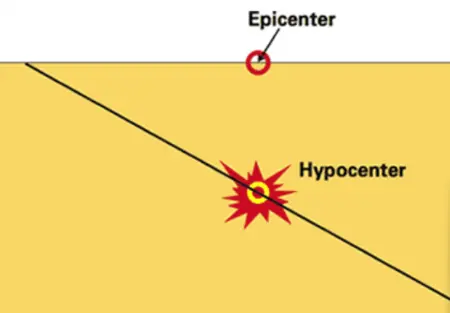
Epicentre: The point above the earthquake’s origin on the surface of the Earth.
Hypocentre (Focus): The specific underground location that the earthquake came from.
Understanding these two important terms is helpful for us to accurately map out intensity and spread of earthquakes.
Seismic Waves: Types & Effect
Seismic waves are the physical vehicles for the energy released from an earthquake.
- Body Waves
Primary waves (P-waves): the fastest of the body waves, can travel through solids, liquids, and gases. They cause compressional motion.
Secondary waves (S-waves): slower than P-waves and can only travel through solids. They cause shearing motion.
- Surface Waves
Surface waves travel only along the surface of the Earth.
Love waves: horizontally traversing and produce a shaking motion in the ground.
Rayleigh waves: rolling motion that typically cause the most damage.
| Wave Type | Speed | Medium | Motion Type | Damage Potential |
|---|---|---|---|---|
| P-waves | Fastest | Solids, Liquids, Gases | Compressional (Longitudinal) | Low |
| S-waves | Slower | Solids only | Shear (Transverse) | Moderate |
| Love waves | Slow | Surface only | Horizontal shear | High |
| Rayleigh waves | Slowest | Surface only | Rolling (Elliptical) | Highest |
Major Earthquakes in History
| Event | Year | Magnitude | Location |
|---|---|---|---|
| Gujarat Earthquake | 2001 | 7.7 | India (Bhuj) |
| Indian Ocean Tsunami | 2004 | 9.1 | Indonesia |
| Nepal Earthquake | 2015 | 7.8 | Nepal |
| Japan Tohoku Quake | 2011 | 9.0 | Japan |
| Turkey-Syria Quake | 2023 | 7.8 | Turkey, Syria |
What Causes Earthquakes?
The shaking of the ground is caused by the sudden release of energy in the Earth’s surface called the crust, which is transmitted outward as seismic waves, in a slightly chaotic way. The rupture and energy release can arise from both natural causes and human activities.
Natural Causes
- Movement along faults: Stress accumulates at faults until friction is overcome and rocks slip instantaneously.
- Subduction of plates: One tectonic plate is pushed under another plate with shallower dips, frequently generating tsunamis and considerable movement.
- Volcanic activity: Tremors can occur from the movement of magma and eruptions from volcanoes.
- Deformation of crust: Continuous pressure within the crust leads to overstress, and hence breaking and faulting.
Manmade Causes ( GC Leong)
- Large Dams & Reservoir-Induced Seismicity (RIS): The strain produced by the enormous weight of stored water leads to increased stress on basal rocks. (e.g Koyna Dam, Maharashtra).
- Mining Activities: Disturbance to crustal stability happens through deep mining and blasting.
- Nuclear Tests & Explosions: Underground nuclear tests also produce shock-waves that can induce earthquake tremors (Nevada, USA; Pokhran, India).
- Oil and Gas Extraction (Fracking): Hydraulic fracturing and other forms of excessive drilling, induce quakes by way of destabilizing faults (induced quakes in Oklahoma, USA).
- Unregulated Urban Development and Over-Construction: The negative impact of heavy infrastructure in seismic zones magnifies the frequency and impact.
- Groundwater Over-Extraction: The over-extraction of groundwater can lead to land subsiding, further leading to weak stability in the crust.
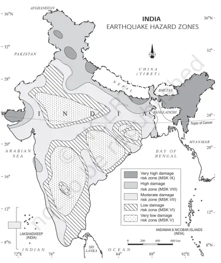
Earthquake Zones in India
The official classification of India based on earthquake hazard zones is provided by the Bureau of Indian Standards – Seismic Zoning Map of India, IS 1893:
1- Zone II (Low Risk)
least active zone.
2- Zone III (Moderate Risk) Reasonable and measurable seismic activity.
3- Zone IV (High Risk)
Cause major damage.
4- Zone V (Very High Risk) – very high intensity zone, may cause extensive destruction and significant ruptures.
(Note: Zone I is no longer utilized in India’s zoning scheme).
Examples of Zones & Major Quakes in India
1- Zone V (Very High Risk): Zone V includes Northeast India, some parts of Jammu & Kashmir, Himachal Pradesh, Uttarakhand, Rann of Kutch (Gujarat), some parts of North Bihar, Andaman & Nicobar Islands.
Example: 2001 Bhuj Earthquake, Gujarat (M 7.7) → 20,000 deaths, losses estimated over ₹15,000 crore.
2- Zone IV (High Risk): Zone IV includes Delhi, parts of Haryana, Punjab, some parts of Bihar, and most of West Bengal, Himachal Pradesh, etc.
Example: 1905 Kangra Earthquake (M 7.8, Himachal Pradesh) → at least 20,000 deaths.
3- Zone III (Moderate Risk): Zone III includes Kerala, Goa, Lakshadweep, some parts of Maharashtra, Andhra Pradesh, Karnataka, Telangana, Chhattisgarh.
Example: 1993 Latur Earthquake (M 6.4, Maharashtra) → at least 10,000 deaths, losses estimated over ₹1,200 crore.
4- Zone II (Low Risk): Zone II includes regions such as Rajasthan, Madhya Pradesh, and central Indian regions.Very rarely does Zone II see major destructive quakes.
Measurement of Earthquakes in India
Scale Used to Measure Earthquake: Richter Scale (magnitude) & Modified Mercalli Intensity Scale (effects and impact).
Agency reporting earthquakes: India Meteorological Department (IMD), Ministry of Earth Sciences is the official nodal agency for monitoring and the reporting of earthquakes.
It operates the National Seismological Network (NSN) with 115+ seismic stations around India.
The Ring of Fire
The Ring of Fire is a horseshoe-shaped zone around the edges of the Pacific Ocean. Moreover, It is home to about 75% of the world’s active volcanoes and experiences around 90% of the world’s earthquakes. It’s formed due to multiple convergent plate boundaries, where oceanic plates subduct beneath continental or other oceanic plates.
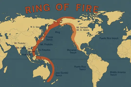
Examples of High magnitude Earthquake around ring of fire
These countries lie along the Ring of Fire and are highly vulnerable to both earthquakes and tsunamis:
– Japan– 2011 Tōhoku earthquake and tsunami (9.0)
– Chile– 1960 Valdivia earthquake (9.5 – strongest ever)
– Indonesia– 2004 Sumatra earthquake and tsunami (9.1)
– Philippines– Frequent volcanic + tectonic activity
– USA (Alaska, California)– San Andreas Fault, Alaska quake
Results of Earthquakes:
Earthquakes can leave effects that go beyond shaking the earth and can be multi-dimensional in nature in terms of consequences for the economy, society, and political stability
Economic cost
- Financial losses can be astronomical given damaged infrastructure, businesses, industries, transport, and boat utility.
- Business closures and unemployment can result with no work for employees.
- Relief and rehabilitation can create massive burdens on government tax and revenue streams.
- A long-term decline in tourism and foreign investments could occur in regions that have experienced earthquakes.
In 2011, the Tohoku Japan Earthquake resulted in $235 billion losses, making it the costliest disaster in history.
Social consequences
- Lives lost, families lost, and children orphaned result, while communities can suffer as a result.
- Survivors may experience trauma, stress, and distress in addition to mental health issues.
- Mass displacement or migration may occur with some individuals and families forced to resettle permanently away from home.
- Communities that are economically poor and vulnerable, will suffer consequences that make them more backward personally and more vulnerable to disaster and consequences of disaster.
- Cultural heritage sites will be physically destroyed due to earthquakes as would the built environment of a community. Destroying belief systems, identities, and history for students and the community.
Political ramifications
- A larger debate about government accountability and questions will arise as to whether a country was prepared for the natural disaster, and/or the government’s response speed.
- In the worst case, if your government doesn’t have strong governance a earthquake, the consequences for both may be disastrous.
- Public unrest may also occur that may involve protests and demonstrations about ineffective relief.
- Natural disasters may also agenda, plans, or priorities for a disaster, such as informing new laws about building codes.
- Bilateral relations may deteriorate should a government receive assistance or aid from the international community .
India’s Earthquake Preparedness
National Initiatives:
- NDMA Guidelines: Enforce safer building codes and retrofit old structures to reduce quake vulnerability.
- Mobile Applications (India Quake & Bhuvan): Provide real-time earthquake alerts and seismic hazard mapping.
- Mock Drills: Build awareness and train communities for effective emergency response.
International Initiatives:
- Global Earthquake Model (GEM): Offers scientific data and risk models for better earthquake preparedness.
- UNDRR: Promotes global cooperation and policies for disaster risk reduction.
- Sendai Framework (2015–2030): Sets global targets for reducing disaster risks and losses.
PYQs on Earthquakes (UPSC Prelims)
The subject of earthquakes is a high-weightage topic in the UPSC context for:
Geography: It relates to both plate tectonics and seismic waves.
Environment: It relates to disaster risk management.
General Studies Paper 1 (Mains) Each year, the UPSC includes questions related to earthquakes in the Mains exam:
UPSC 2013: Describe the difference between the epicentre and hypocentre of an earthquake.
Mains UPSC 2016: Rank the types of seismic waves in order of destructive ability.
UPSC 2020: Discuss the basis of India’s earthquake classification system.
Conclusion
While earthquakes cannot be prevented, effective preparedness can assist in reducing the negative impacts that come from earthquakes. Recent earthquakes in Taiwan, Afghanistan-Pakistan, and India remind us, the risk from seismic activity, is a constant regional and global hazard. Global and national strategies, enhanced infrastructure, and awareness allow the world to head towards safer communities.
FAQ’s
Most earth quakes are caused by a sudden release of stress accumulated along geological or tectonic plates, that causes displacment of the rock.
Countries in the Ring of Fire such as Japan, Chile,Indonesia, and the Philippines are most prone to earthquakes.
Magnitude – The energy released (measured on the Richter or moment magnitude scale).
Intensity – The observed effects and damage in the area (measured on the Modified Mercalli Intensity Scale).
No, earthquakes cannot be predicted accurately. However, risk zones and probabilities can be evaluated.
Drop, cover and hold.
Stay away from windows.
If you are outside, move to an open area.