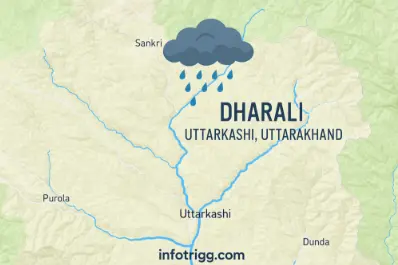
On 5th August 2025, the sleepy village of Dharali, close to Harsil Valley in the Uttarkashi district of Uttarakhand experienced a cloudburst which caused flash floods and landslides, all of which wreaked havoc on the delicate Himalayan environment. The cloudburst resulted in the loss of lives and damaged some twenty plus houses, and blocked many critical routes including the Char Dham Yatra route to Gangotri Dham.
This demonstrates the higher vulnerability of Himalayan regions to extreme weather events, which is becoming more frequent due to climate change, unchecked construction and deforestation in the world’s most biodiverse mountain system. The cloudburst at Dharali also evokes the haunting memories of the Kedarnath cloudbursts and glacial lake outburst flood of 2013 which resulted in more than 5000 deaths.
“The Himalayas are not just a young fold mountain system – they are an alarm system for climate change.”
– The National Institute of Disaster Management (NIDM) reports
These events are of great significance to UPSC aspirants, especially in Prelims (cloudbursts, monsoon behaviour, geography of the Himalayas), and Mains GS Paper 1 and 3, geophysical hazards (climatic hazards), geomorphology, and disaster management. Importantly, the Dharali case highlights that India must not only develop its most disaster-prone landscapes and terrains in a climate-resilient manner but also strengthen early warning systems and, furthermore, plan development with greater eco-sensitivity.
What is a Cloudburst?

A cloudburst is a brief but very intense rainfall event that takes place over a small area in a short period of time, often resulting in flash floods and landslides. The India Meteorological Department defines a cloudburst as rainfall of 100 mm or more in an hour over an area of about 20–30 square kilometers.
To understand how it happens, we need to go back to the basics of geography and weather science.
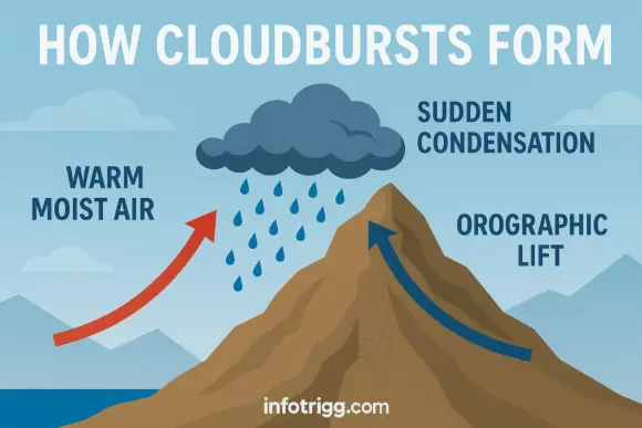
- In mountainous areas like the Himalayas, steep gradients rapidly lift warm, moist air from the plains — a process known as orographic lift.
- As orographic lift occurs, the air volume rises, and it cools quickly, and the moisture condenses into clouds.
- When clouds receive too much moisture and condensation occurs rapidly (and the air cools faster), the water releases precipitation, which occurs intensely at cloudburst time. That is a cloudburst.
Cloudbursts — unlike regular rainfall — are also hyperlocal: they happen in a small area, and they occur within a short timeframe (normally within one hour). Along with rainfall, the event of a cloudburst can also involve hailstorms and lightning/falling tree branches, so they can also be dangerous.
These are especially common in Himalayan regions such as Uttarakhand, Himachal Pradesh, and Jammu & Kashmir due to the high altitudes, unstable atmosphere, and very steep topography that are conducive to the rapid vertical movement of moist air.
Impact of Cloudbursts (With real-life examples)
- Flash Floods– Example: Kedarnath, 2013 – A cloudburst and glacial lake outburst resulted in flash flood that wiped out entire towns such as Rambara. The disaster killed over 5,000 people, making it one of India’s deadliest recent natural disasters.
- Landslides -Example: Chamoli, Uttarakhand, 2021 – While a glacier break primarily caused the event, the associated cloudburst caused slope failure and debris flows. The landslide buried two hydropower plants and left over 200 workers miss
- Loss of Life and Infrastructure– Example: Leh Cloudburst, 2010 – Monster torrential rain caused extensive damage to Leh town in Ladakh. Consequently,the disaster severely impacted infrastructure, damaging roads, hospitals, and residential homes. As a result, it killed around 200 people, left 300 missing, and damaged or destroyed over 1,000 houses.
- Disruption of Pilgrimages– Example: Badrinath route, 2022 – Several instances of cloudburst along the Char Dham Yatra disrupted thousands of pilgrims. As a result, Helicopter operations were required to rescue pilgrims as the roads were cut off.
- Agricultural Damage– Example: Himachal Pradesh, 2023 – A series of cloudbursts during the monsoon season destroyed apple orchards and vegetable farms. As a result,Farmers from Kullu and Shimla district reported 50% crop damage.
- Changing River Courses -Example: Mandakini River (post-Kedarath, 2013) – In the case of Mandakini, the cloudburst altered the river’s course and consequently increased the risk of erosion and flooding for municipalities downstream.
Forecasting and Monitoring Cloudbursts
Cloudbursts occur in a hyper-localized area (20–30 sq. km) and release intense rainfall in less than an hour, making it extremely difficult for conventional forecasting systems to predict them accurately due to their limited spatial and temporal coverage.
Doppler Radar
Doppler Weather Radars (DWRs) are essential for detecting high-intensity rainfalls and any cloud build-up. Asian sub-continent countries like India use them less frequently because rugged terrain, lack of required infrastructure, and line-of-sight issues hinder effective deployment.
Example: Sensitive topological zones in Uttarakhand and Himachal Pradesh still remain outside radar coverage.
IMD Action
“Cloudburst forecasting has many technical challenges. The Doppler Radar network is growing rapidly, especially in vulnerable hilly areas,” the IMD stated in its most recent annual weather review statement.
The India Meteorological Department (IMD) is currently:
- Firstly, Taking strides on improving the forecast system for cloudbursts,
- Additionally, they Continue to develop and create high-resolution weather models (meso-scale models of 1-3 km resolution)
- Also, Expanding the number of Doppler Weather Radars in hill states.
- Moreover, Regularly posting on the IMD official website and the “Mausam” mobile application with the real time updates.
Post-Event Mapping by ISRO:
Indian Space Research Organisation (ISRO) is actively involved in natural disasters post-event mapping using satellite data (Cartosat, RISAT, INSAT) to perform post-disaster impact assessments through mapping the affected areas and to assist with plans for search and rescue.
India can take technological inspiration from Japan Meteorological Agency (JMA) as they utilizes X-band phased array Doppler radars, utilizing minute-by-minute updates, which focus on urban flooding alerts using good accuracy for localized heavy rain forecasting.
Similarly, United States –The National Oceanic and Atmospheric Administration (NOAA) uses a Dense network of radars and
- GOES satellites (for cloud tracking in near real-time) and
- Employs Advanced Numerical Weather Prediction (NWP) models that integrate artificial intelligence to predict possible flash flood zones.
Read about India-US trade deal and space collab
Disaster Preparedness & Response
NDMA Guidelines:
The National Disaster Management Authority (NDMA) developed strategies for disaster preparedness using some of these essential considerations including:▸ early warning systems using Indian Meteorological Department forecast in map-based formats,
▸ planning and drills for evacuating high risk zones,
▸ codes of structural safety and construction in hill areas
▸ planning community awareness strategies for villages that are vulnerable and aware of risks and dangers selected by local community members.
Quick Response Teams:
Uttarakhand’s State Disaster Response Force (SDRF) and National Disaster Response Force (NDRF) were immediately deployed to carry out search, rescue, and relief work in the Dharali incident (2025). This action is an important part of India’s layered disaster response system.
Infrastructure Resilience:
There is a strong need to enhance the resilience of roads, bridges, and communications networks, especially on pilgrimage circuits such as the Char Dham Yatra, which are increasingly coming under threat from extreme weather.
Eco-sensitive Planning:
Sustainable construction, regulating tourism infrastructure, and conducting Environmental Impact Assessments (EIAs) of planned mitigation works in ecologically sensitive areas should be prioritized to reduce vulnerability to disaster.
UPSC relevance
Prelims (GS Paper 1 – Objective)
Cloudburst: Definition and meteorological aspects as defined by the IMD
Causes: Orographic rainfall, monsoon winds, localized convection
Map based questions: Location of Dharali, Uttarkashi, and Bhagirathi river system
Technology: Role of Doppler Weather Radars, INSAT, Megha-Tropiques, and Cartosat
Mains – GS Paper 1 (Geography)
Climatic Hazards in the Himalayas
Geomorphology and slope failure
Role of unplanned development and deforestation
Mains – GS Paper 3 (Disaster Management)
BS role of NDRF and SDRF institutions.
Disaster management in ecologically fragile areas
Early Warning System and infrastructure deficiencies
Need for eco-sensitive tourism and development planning
Global Trends and Concerns:
The IPCC’s Sixth Assessment Report noted that rising global temperatures are tied to an observed increase in the frequency and intensity of extreme weather events. The report referenced cloudbursts, flash floods, and heavy precipitation. The rise in global temperatures has resulted in an increase in moisture in a warming atmosphere, approximately 7% more moisture per 1°C, which will generate heavier precipitation events.
Cloudbursts Are Not Exclusive to India;
▸ Cloudbursts or similar sudden deluges have happened in Japan (Kyushu, 2020), China (Zhengzhou floods, 2021), Europe (Germany floods, 2021), and parts of the Rocky Mountains (USA).
▸ In 2024, rapid urban development likely played a role in exacerbating urban flash floods in Dubai caused by cloudburst like rainfall in the arid region.
Why They’re Happening More Often Around The World:
▸ Additional incursion of urbanisation/concrete sprawl into urban heat islands, deforestation, and climate-driven changes to monsoon and jet streams.
▸ Global dialogue and action — with initiatives such as the Sendai Framework for Disaster Risk Reduction, UNDRR, and the Paris Agreement – acknowledge the importance of adaptation to climate.
Currently, there is an emphasis on investing in climate-resilient infrastructure, creating early warning systems, and developing the capacity of local communities.
Conclusion
The Dharali cloudburst of 2025 wasn’t just another discrete weather event; it was a distinct signal that India’s mountain ecological systems are fragile and are being disrupted by climate change, indiscriminate development, and inconsistent forecasting systems. It calls upon policymakers, planners, and citizens to invest in climate-resilient infrastructure, develop scientific monitoring systems, and ensure community awareness and preparedness.
For UPSC aspirants, the event weaved together many current affairs issues with static concepts from geography and disaster management. Understanding cloudbursts is not merely about knowing definitions; it is critical to know more about the environmental, policy, and resilience conditions we face in a warming world.
Read More about UPSC content on Infotrigg.com
Read more: Why Cloudbursts Matter for UPSC? Dharali 2025 Case Study- Rare Earth Minerals & Critical Minerals – India in the Global Context

- Securities Transaction Tax (STT)– Meaning, Budget Change & Market Impact

- FRBM Act , 2003: Background, Provisions and Significance for UPSC

- Ocean Currents: Causes, Types and Global Distribution for UPSC

- POCSO Act 2012 UPSC: Key Provisions & SC Debate


